Topographic Mapping

Fields, isolines, profiles, and gradient

Topographic Mapping

Why maps have lines on them

  • A topographic map shows a three-dimensional landscape on a two-dimensional sheet of paper
  • Slice the mountain at even elevations, look straight down at the slices, and you get contour lines
  • Each line traces one elevation all the way around the landform

Topographic Mapping

Mapping the Earth: terms

  • Field — any region of space that has a measurable value of a given quantity at every point
  • Isoline — a line connecting points of equal value
  • Isotherm — a line connecting points of equal temperature
  • Isobar — a line connecting points of equal pressure
  • Contour line — a line connecting points of equal elevation

Iso- means "equal." Change the ending, change the quantity being mapped — the rules for drawing the lines never change.

Topographic Mapping

How to draw an isoline

  1. Connect dots of equal value, using the interval stated in the directions
  2. Where the exact value isn't printed, estimate where it falls between a higher point and a lower point
  3. Bring every isoline all the way to the edge of the field

Topographic Mapping

Rules isolines never break

  • Isolines never cross each other — one point can't have two values
  • Isolines never split or branch
  • Isolines close into loops or run off the edge of the map
  • Values change in order — you can't skip from 40 to 60 without a 50 in between
  • Lines close together = value changing quickly
  • Lines far apart = value changing slowly
Topographic Mapping

Practice: draw the isotherms

  • Surface temperature field for the central U.S.
  • Draw contours every 10 °F
  • Then reveal the answers and check your work
  • courseware.e-education.psu.edu → meteo101 → Lesson 2 contour tool

Topographic Mapping

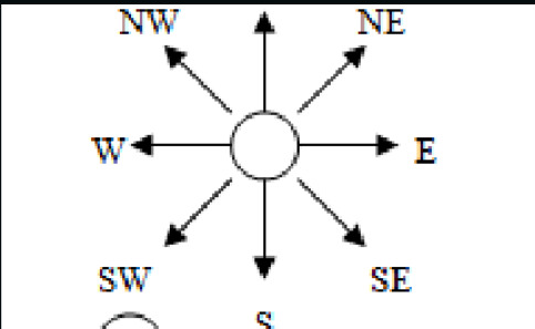
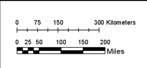
Map scale and direction

Map scale — the ratio between distance on the map and actual distance on Earth's surface.

Cardinal directions — north, south, east, west, and any combination (NE, SW, …).

Topographic Mapping

Making a profile — steps 1 and 2

  1. Line the edge of a piece of scrap paper up with the two points on your map
  2. Mark the two endpoints on the scrap paper, plus every contour line that falls between them

Topographic Mapping

Making a profile — step 3

Write the value of every mark you made on the scrap paper.

Line the paper edge up with the x-axis (first point at the origin) and plot each elevation against the y-axis.

Topographic Mapping

Connect the dots

Join your points with a smooth curve — this is the side view of the land along the line

Topographic Mapping

Round out your peaks

  • The land keeps rising past the last contour line you crossed, so a hilltop is rounded, not pointed
  • Valley bottoms get rounded for the same reason
  • Straight lines and sharp points receive no credit

Topographic Mapping

Contour lines over a stream

  • Contour lines bend where they cross a stream
  • The bend makes a "V" that points upstream
  • Water flows downhill, so the stream flows opposite the direction the V points
  • Streams run from high elevation toward low elevation

Topographic Mapping

Gradient

  • Page 1 of the ESRT
  • Describes how steep a slope is
  • The closer the isolines are in a given distance, the larger the gradient

Topographic Mapping

Gradient example

Point A is at 123 feet. Point B is at 20 feet. The two points are 2 miles apart. What is the gradient?

DON'T FORGET UNITS! Equation → substitution → answer with units, every time.

Topographic Mapping

Draw It

Your turn

Topographic Mapping

Try this one

Point A elevation: 260 feet
Point B elevation: 10 feet
Distance between the points: 3 miles

Find the gradient. Show the equation, the substitution, and the units.
Topographic Mapping

Check yourself

  • Equation comes from page 1 of the ESRT
  • Subtract low from high for the change in field value
  • Units are feet per mile — the unit tells you it's a rate
Topographic Mapping

Before you leave

  1. What does a contour line connect?
  2. Two maps show the same hill. On map X the contours are crowded; on map Y they are spread out. Which hill is steeper, and why?
  3. A stream crosses a contour line. Which way does the V point?
  4. Why must a profile have a rounded top instead of a sharp peak?